DJI improves geofencing to protect European airports and facilities
'GEO 2.0' provides more sophisticated data to 32 European countries
DJI geofencing uses GPS and other navigational satellite signals to prevent drones from flying near sensitive locations such as airports, prisons, nuclear power plants and high-profile events. These no-go-zones are high safety risks areas where drones cannot take off, or fly into, without special authorisation.
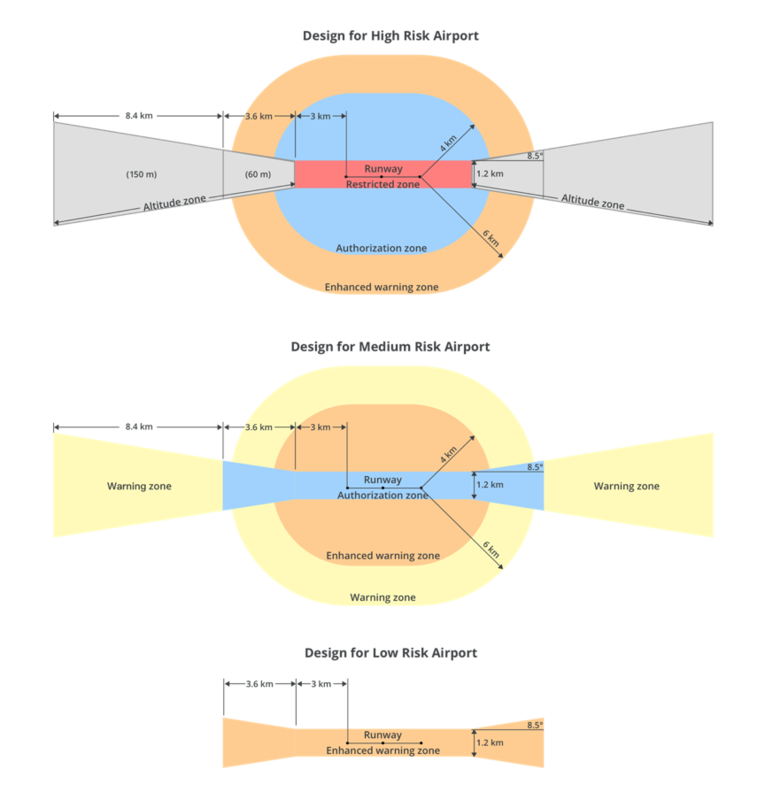
DJI’s new geofencing system, GEO 2.0, is powered by data from Altitude Angel and includes detailed 3D ‘bow tie’ shaped safety zones surrounding runway flight paths. It also represents the virtual perimeter around sensitive areas more accurately than the original GEO system. Complex polygonal shapes replace simple circles.
The new system is also more flexible in lower-risk areas. For instance, it allows authorised drone users to conduct drone activities in locations parallel to runways.
This applies in the 13 countries originally covered by AirMap, as well as in 19 new European countries that now have advanced geofencing.
This system also includes Temporary Flight Restrictions (TFRs) that can be imposed during major events or natural disasters. The TFRs are based on authoritative data from Eurocontrol (The European Organisation for the Safety of Air Navigation).
“We are pleased that DJI has upgraded its geofencing system. GEO 2.0 is a positive improvement for the industry and it will make the skies even safer.”, said FPV UK CEO Simon Dale.
This chart provided by DJI shows how GEO 2.0 uses more detailed risk-based data, distinguishing between high, medium and low risk zones.
The Community
DroneHub - the FPV UK drone community hub
Connect with our super-friendly drone community
Join us on DroneHub.co.ukWorking With